
遇到问题及现象
使用openlayer实现地图掩模效果 类似高德上的区域掩模效果
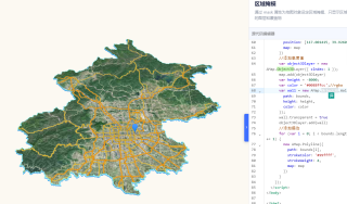
目标效果--高德上的区域掩模效果
相关代码
//海宁区域
_that.areaLayer = new VectorLayer({
          name: '海宁区域',
          source: new VectorSource({
            url: '/data/HainingArea.geojson',
            format: new GeoJSON()
          }),
          style: new Style({
            stroke: new Stroke({
              color: 'rgba(16, 66, 118, 0.6)', //'#1E71B8',
              width: 6
            }),
            fill: new Fill({
              color: 'rgba(50, 103, 174, 0.1)' // 'rgba(50, 103, 174, 0.1)' //'rgba(15, 62, 115, 0.1)'
            })
          })
        })

// 创建卫星图图层
        _that.satelliteLayer = new TileLayer({
          name: '海宁卫星区域',
          source: new XYZSource({
            url: 'https://server.arcgisonline.com/arcgis/rest/services/World_Imagery/MapServer/tile/{z}/{y}/{x}',
            maxZoom: 19
          })
        })

// 创建地图视图
        const view = new View({
          center: fromLonLat(_that.Coordinates, 'EPSG:3857'),
          zoom: 11.4,
          zIndex: 8,
          maxZoom: 18,
          minZoom: 6,
          projection: 'EPSG:3857'
        })

window.map = new Map({
                target: 'map',
                layers: [
                  _that.satelliteLayer,
                  _that.areaLayer,
                  _that.waterLayer,
                  _that.riverLayer,
                  _that.riverBoundaryLayer
                ],
                view: view,
                extent: [120.30239196, 30.24771399, 120.87324612, 30.59070399], // 设置地图限制范围
                controls: defaultControls({
                  //加载控件到地图容器中
                  zoom: false,
                  rotate: false,
                  attribution: false
                })
              })


